A mermaid’s tail: Exploring water heritage in the city of Hull
- Sep 29, 2025
- 8 min read
Updated: Oct 1, 2025
Written by Katerina Velentza, Ed Brookes, Hannah Worthen, Lauren Saunders, Briony McDonagh, Kate Smith and Gill Hughes, the Community Waterscapes team at the University of Hull.
The history of Kingston-upon-Hull, in northern England, has always been shaped by water. Tracing its origins to the initial settlement of Wyke in the late twelfth century, Hull was established in its current location after the course of the river Hull was altered by disastrous flooding in the thirteenth century. In the 700 years since then, Yorkshire’s maritime city has been a port of international importance to transport, fishing, trade and exchange [1].
Perched on low-lying land where the Humber and Hull rivers meet, with direct access to the estuary, the North Sea, and inland routes via the Trent and Ouse, the city’s very existence was shaped by its waterways.
These advantages came at a cost, with flooding a constant threat to the city and its neighbours. Yet the lifelines of trade, travel, and resources that water delivered outweighed the danger, maintaining the prominence of the city in the region into the twenty first century.

This deep connection with water, however, entered a new chapter in the late twentieth century, one marked less by opportunity and more by challenge. The collapse of the local fishing industry, the closure of the Victoria and St Andrew’s docks in the 1970s, and the arrival of the Tidal Surge Barrier in 1980 changed the city’s relationship with water. No longer was the city reliant on water for industrial and economic prosperity, instead it became something to be managed and kept at bay. Also, as the city’s watercourses were ‘culverted’ and redeveloped, many of the local drains and dikes were hidden from view, becoming far less visible to residents than they once were. These changes have reshaped how people interact with water in the city, something that previously defined the city’s history and culture[2] At the same time, the city’s historical flood risk has intensified in the last two decades by climate change [3]: the city is ranked second only to London for its flood risk in England[4]. Now more than ever, there is a need for communities to come together to discuss, explore and understand their relationship with water.

The University of Hull Community Waterscapes [5], in partnership with local communities and organisations (including Hull Maritime [6] & the Living with Water partnership [7]), is exploring the city’s rich watery heritage in response to this disconnect. Building on the work of the Risky Cities[8] project, the emphasis in Community Waterscapes has been on working with communities to create a space for dialogue around the city’s past through participatory, history and heritage workshops. In doing so, residents of Hull have been invited to identify, record and share what they consider to be significant watery heritage in the places they live and work reflecting on what it means to live in a dynamic watery environment.

Communities come together to map their watery heritage
Since the summer of 2024 we have been collating a community-led heritage record of people’s connection to water and recording this in a digital Story Map[9]. This involves both tangible and intangible heritage such as significant landmarks and buildings around the city, favourite walks, changing landscapes, lived experiences of flooding, experiences of sailing or living by the water, local knowledge related to the dynamic Humber estuary, and multi-generational family histories of working in the maritime industry.

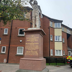


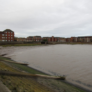
Significant Hull buildings and landmarks. Left: Fishermen's Memorial on Hessle Road. © Community Waterscapes. Middle left: East bank of the river Hull. © Community Waterscapes. Middle right: The old harbour on the river Hull with shipping traffic in 1977. © Andrew Jackson. Right: The Lord Line building, even though abandoned, has a significant meaning for local community groups and artists offering ‘amazing views of the Humber Estuary’. It has been described as an ‘example of abandoned commons that could be better put to public use'. © Petra Codato.
This community-led approach to heritage research has deepened our understanding of how people interpret their relationship with local aquatic environments and how this has changed over time due to various socio-economic transformations that have occurred in the city in the last few decades.


Left: Newspaper clipping , 1969. The hand-written note says: “My dad's car”. Our workshop participant brought this and described how, as a child, he cut and kept this newspaper clipping from the Hull Daily Mail, because it showed his dad’s car stuck under Chanterlands Avenue bridge during the flood of the 29th of September 1969. © Mike Hood. Middle: Victoria Dock operated between the mid-19th century and 1970. In the late 1980s it was redeveloped for housing offering opportunities for people to live alongside the Humber Estuary. © Community Waterscapes. Right: Family photographs belonging to Susan Woolhouse. Several of her family members worked in the fishing industry and had experiences of work in the North Sea. © Community Waterscapes.
Celebrating water heritage by the mermaid fountain

If you’ve ever visited Hull, you may have seen a mermaid fountain, but where exactly depends on when you were looking. As part of the project’s creative collaboration with Hull residents, Community Waterscapes worked in partnership with the visual artist and activist Lauren Saunders[10], who bridges human and more-than-human perspectives on nature and the climate crisis, organising a participatory artistic session celebrating Hull’s water heritage through the mysterious and mythical mermaid. Inspired by stories of the mermaid fountain gathered during our community mapping workshops, the event took place at the Western Library in May 2025.

The fountain itself has lived a wandering life: first at the city’s Zoological Gardens (mid-nineteenth century), then Pearson Park (late nineteenth century–1951), later at ‘Fletchers Corner’ on Jameson Street and King Edward Street (c.1956) outside Fletchers bakery (now LUSH), before finding its current home at the Western Library in 2013.
Stories of the fountain at Fletchers Corner were something many residents were keen to share in our workshops, as they reflected on how the mermaid was a good spot to meet or sit while eating sausage rolls from the bakery[xi]. These memories, combined with the often-enigmatic movements of the statue throughout the city, meant that the mermaid became the focal point of our celebration and a jumping off point through which to expand dialogue around the city’s watery heritage.


Left: Lauren Saunders. © Lauren Saunders. Right: Wild Dialogue (2025), Lauren Saunders, Mixed Media Installation, Unfolded: University of Hull Gallery. © Lauren Saunders.
Reflecting on the event, artist Lauren Saunders shared her experience of the project and how she curated a set of watery stories to connect people with the mermaid and the city’s history:
“I was excited to be invited to take part in the Community Waterscapes project to creatively explore the mermaid fountain at the Western Library, as a symbol of Hull community’s connection to water. The project offered a valuable opportunity to experiment with new participatory storytelling approaches in collaboration with communities, set against the backdrop of Hull’s maritime and environmental heritage.
The statue sits at the heart of Hull’s historic Hessle Road fishing, frequently disadvantaged, community, and I was drawn to the rich overlap between local history, mythical mermaids, and seafaring superstition.
Mermaids symbolise the importance of respecting the sea, an idea that deeply resonates with my commitment to fostering a non-hierarchical relationship with nature.
I have found that within the underfunded, working-class communities I work alongside, many face barriers to nature connection, including fear of the outdoors, lack of ecological knowledge, discomfort with spiritual connection, or a purely utilitarian view of nature.
To bridge these gaps, in Community Waterscapes I shifted my practice toward playful, participatory storytelling that draws on theatrical suspension of disbelief, familiar archetypes, original lore, and a touch of magic. My goal has been to create welcoming, low-pressure opportunities for audiences to (re)discover place, reconnect with nature, and engage with British indigenous perspectives on land connection.”

At the final Community Waterscapes event in Hull’s Western Library, Lauren wove together storytelling, theatre and watery worlds through playful activities where visitors wrote messages to mermaids in bottles, designed shimmering tails, mapped sightings across the city, dressed up in costume, sculpted clay kinfolk, and uncovered a treasure chest of seabed curiosities —each inviting new stories of the mermaid and her companions to surface.


Left: Create-a-Tail worksheet with a mermaid that “helps lost sailors navigate”. © Community Waterscapes. Middle: The Community Waterscapes event at the Western Library in May 2025. © Community Waterscapes. Right: Textile artwork by Lauren Saunders accompanying the children’s costume box. © Community Waterscapes.
Lauren reflected on how each of these activities and the props they revolved around
“invited participants to artistically explore the local heritage, while inventing new origin tales, building shared mythos around the mermaid, and allowed them to immerse themselves in the idea of living by the water.”
Through these participatory activities, the mermaid became an approachable symbol for the Hull community. This was especially the case for younger audiences, as it enabled them to think about life by the Humber Estuary and the North Sea while more tangibly exploring the city’s rich watery heritage.

The mermaid and the many storytelling activities facilitated by Lauren were not the only aspects of the city’s history open to the public at the event, which included an interactive display of the Community Waterscape Story Map – where visitors of the library could explore and add to the map of watery heritage recorded in previous Community Waterscapes heritage workshops. We were also able to include a handling collection donated to the project by Hull Maritime, a series of maritime artworks by Ian Pearson, George Bell and a soap sculpture provided by LUSH (outside whose city centre store the statue was previously situated).
The result was a community co-created day of celebration, learning and storytelling. In celebrating the mermaid’s tale, the project facilitated a space for Hull's communities to rebuild their relationship with water, a connection that will be vital in navigating the challenges still to come.

References
[1] Atkinson, D., McDonagh, B. McKeon, S., Salter, E., Starkey, D.J. and Wilcox, M. (2017) Introduction, in Starkey, D.J., Atkinson, D., McDonagh, B., McKeon, S. and Salter, E. (eds) Hull: Culture, History, Place, pp.1-13. Liverpool: Liverpool University Press.
[2] See more about significance of watery histories and water identities in Hull in: Smith, K., McDonagh, B., & Brookes, E. (2024). Place-Based Arts Engagement and Learning Histories: An Effective Tool for Climate Action. Environmental Communication, 19(2), 273–293. https://doi.org/10.1080/17524032.2024.2382473
[3] Coulthard, T.J. and Frostick, L.E., 2010. The Hull floods of 2007: implications for the governance and management of urban drainage systems. Journal of Flood Risk Management, 3 (3), 223–231. https://doi.org/10.1111/j.1753-318X.2010.01072.x
[4] ARUP. (2019). City water resilience approach: City characterisation report, Hull’. Available via ARUP. https://www.arup.com/perspectives/publications/research/section/city-characterisation-report-hull(open in a new window). Accessed 19th June 2025.
[5] Funding for the project was provided by the University of Hull’s Arts and Humanities Research Council Impact Accelerator Account, and supported by Hull Maritime Museum & Living With Water partnership.
[6] Hull Maritime: https://maritimehull.co.uk/
[7] Living with Water partnership: https://livingwithwater.co.uk/
[8] Risky Cities project, University of Hull: https://riskycities.hull.ac.uk/
[9] Community Waterscapes digital storymap: https://storymaps.arcgis.com/stories/837437867e1546a4b07e140318087cf8
[10] Lauren Saunders Art: https://laurensaundersart.co.uk/
[11] See Community Waterscape Story Map, case study 22: https://storymaps.arcgis.com/stories/837437867e1546a4b07e140318087cf8


Comments